


News
By Eric Cova, May 7, 2026
Adam Paul Susaneck, the urban designer and filmmaker who helped Smart Growth America visualize the destruction of neighborhoods in Washington, D.C., and Atlanta for Divided by Design, has released a new documentary examining the history and future of the Brooklyn-Queens Expressway. In this interview, Adam reflects on what the BQE reveals about the origins of divisive infrastructure, what he learned while making the film, and what decision-makers should take away as communities rethink aging highways.
At Smart Growth America, an important part of our work is telling the story of how transportation and land use decisions made decades ago continue to shape opportunity, wealth, mobility, and public health today. In Divided by Design, we examined how highway construction tore through neighborhoods in Washington, D.C. and Atlanta, displaced thousands of residents, and, for the first time, quantified the long-term loss of generational wealth and city tax revenue. To help tell that story visually, we partnered with Adam Paul Susanek, whose powerful animations brought that history to life.
Watch “The Story of the BQE” here
Now, Adam has released a new documentary exploring one of the earliest and most influential examples of divisive infrastructure: the Brooklyn-Queens Expressway (BQE). I sat down with Adam to talk about what the BQE reveals about the origins of urban highway construction, how those decisions shaped communities in New York City and across the country, and what policymakers should keep in mind as they make decisions about the future of aging infrastructure.
You’ve created a number of shorter videos tracing how highways cut through communities through Segregation by Design. What made you decide the BQE story needed the depth of a full documentary?
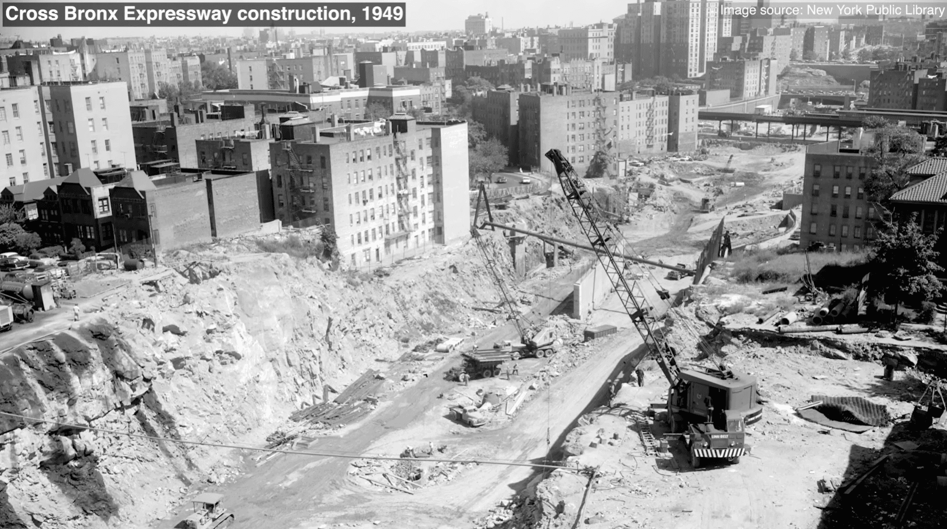
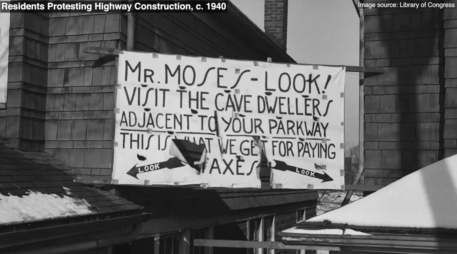
With Segregation by Design, I’m trying to tell (and show) the story of how highways and associated urban renewal projects divided up and essentially destroyed large portions of nearly every American city—at the particular expense of non-white residents and neighborhoods. The BQE and the nearby Cross Bronx Expressway are really two of the first modern highways to be built in this way. As Caro notes in The Power Broker, they were the first to be built through an established city, rather than through sparsely developed areas (like the earlier Autobahn and other examples), and their construction resulted in the displacement of tens of thousands. Through these projects, their designer, Robert Moses, pioneered the tactics that would later be used to cut highways through neighborhoods in other parts of the region, routing through low-income, immigrant, and non-white communities (while claiming the goal of “blight elimination”) to support the growth of racially-restricted suburbs on the periphery of the existing city.
So, to tell the story of the highways, the story of the BQE is the perfect starting point.
In Divided by Design, Smart Growth America documented how highway construction tore through and devastated communities across the country. Where does the BQE fit into that national story, and what makes its impact in New York distinct?
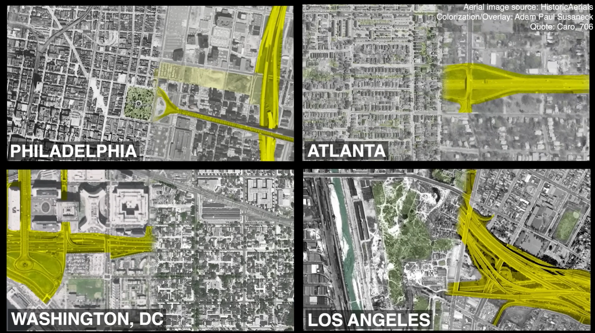
By the time the 1956 Federal Highway Act was created, which funded the construction of the Interstate Highway system as we know it today, the BQE was largely complete. As other cities are constructing their highway networks, leaders and highway engineers looked to Robert Moses’ practices in New York for inspiration. Caro notes that Bertram Tallamy, the first federal highway administrator, frequently collaborated with Moses, who “was not merely the friend of the federal road builders—he was their idol.”
So, in a lot of ways, the BQE and the Cross Bronx become the template for how other cities would build their highways, and for how governments can use publicly funded transportation projects to achieve ends other than purely transportation. This is particularly true in the overall orientation of these urban highway networks, specifically towards facilitating further suburban growth, rather than merely connecting between existing locations or supporting freight movement.
Moses designed the network in New York to facilitate easy automobile commutes between the growing suburbs of the Tri-State Area and the economic core in Lower Manhattan—cutting through existing neighborhoods in between. This was in an era, especially prior to the Civil Rights Movement in the 60s, where many of these new suburbs were explicitly “whites only” due to practices such as restrictive covenants. So Moses was creating a system that was to the benefit of mostly white suburban residents at the direct expense of the increasingly non-white urban residents along the way (who, back then and today, are much less likely to have cars).
This sort of network topology is widely adopted around the country. The Interstate doesn’t just become about inter-city travel; much of the network, as constructed, is focused on intra-city and regional travel. Within the urban context, in basically every medium to large city in the US, the highways become about facilitating the connection of the suburbs with Downtown jobs. Downtown leaders welcome the clearing of “inner city” neighborhoods to make way for highways, which, as Deborah Archer notes, become seen as a way to “kill two birds with one stone”: eliminate neighborhoods viewed as a drag on downtown property values, while replacing them with better connections for suburban commuters (all “on Uncle Sam’s dime”).
What makes New York (and the region) “distinct” is that this process was really incubated and perfected here, before being exported to the rest of the country. There’s a reason we specifically talk about Levittown on Long Island in history books around the country as the prototypical example of the first modern automobile suburb. What we don’t often show is that many early advertisements for Levittown proudly proclaimed the new development as “whites only.”
You collaborated with Beth and our team on Divided by Design. How did that experience shape how you approached this documentary?
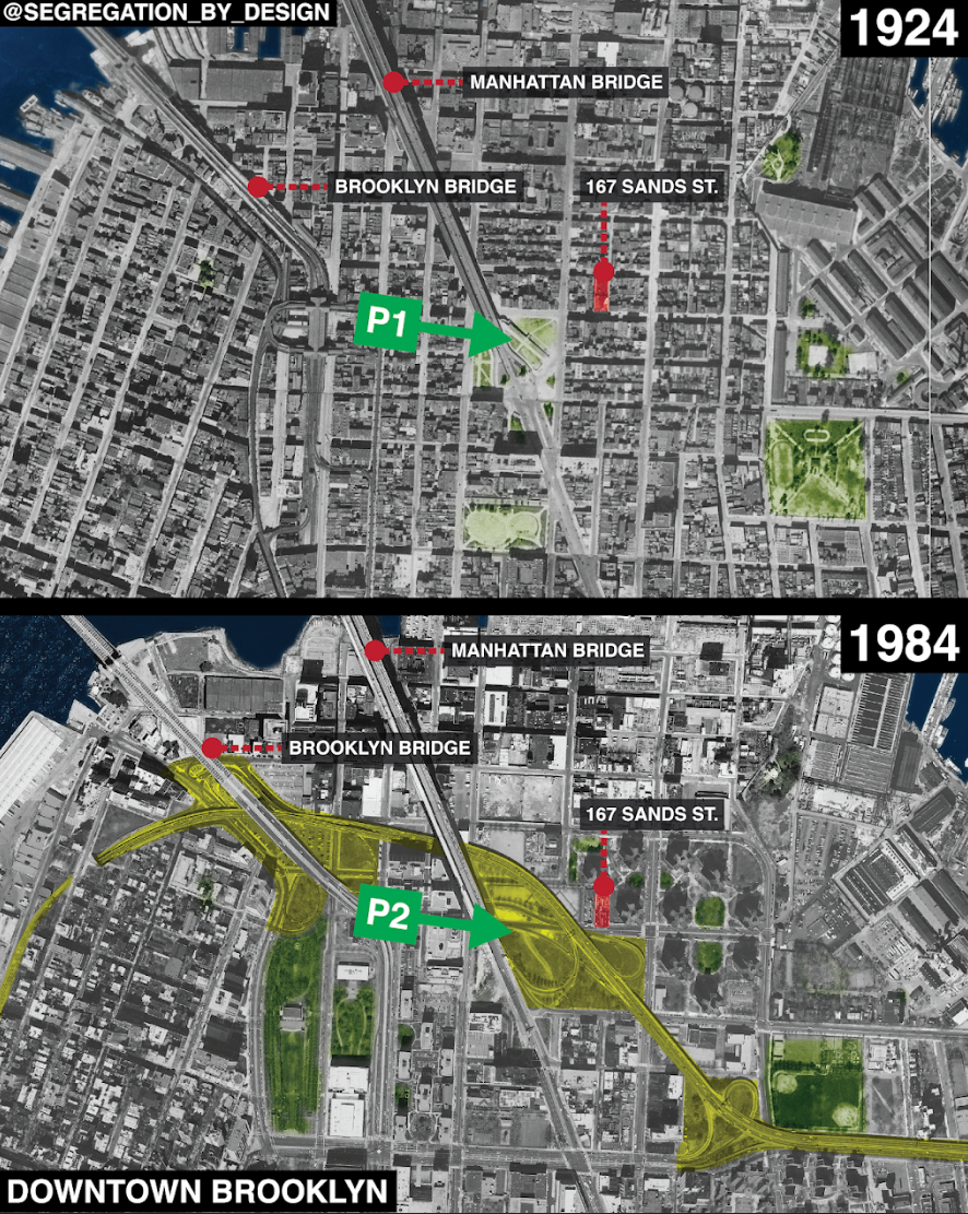
It was exactly Divided by Design I was thinking of when focusing on Downtown Brooklyn. In Divided by Design, SGA calculated the value of the loss in average home equity from those displaced by highway construction in DC and Atlanta. DC was roughly $500k, and Atlanta was roughly $600k. Those amounts are tragic—they represent precisely the generational wealth that was robbed from those displaced in construction.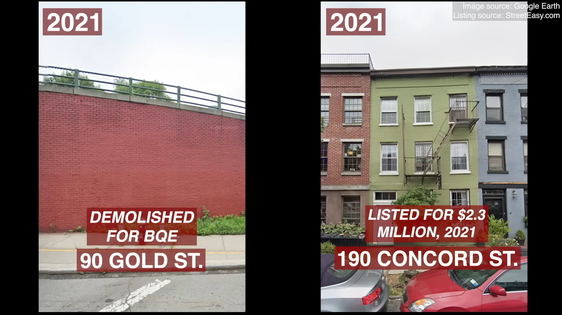
In the video, I take a moment to compare two identical units in Downtown Brooklyn, one that was demolished and one that survived to this day. The one that survived was recently listed for $2.3m. Especially for non-white residents, whose housing was already restricted and who were unable to buy in the suburbs, this became, essentially, a generational setback financially.
Divided by Design also described how “the current approach at all levels consists of ingrained, decades-old transportation policies, funding systems, models, and measures which have their roots in that same history.” This is something I keep in mind throughout my work on Segregation by Design, specifically focusing on how these methods and metrics came to be. Because this is the “systemic” part of “systemic racism.” While the people designing these roads today are probably not racist—and labeling them as such is counterproductive—the systems which have been put in place over the decades ensure that there will be racially biased outcomes.
In so many cases, the rules and regulations supporting our current mobility regime were devised in the era where racialized suburbanization and the creation of “9-5” Central Business Districts was the explicit goal. They were created when the Federal Housing Administration’s official “Underwriting Manual and Valuation Procedure” specifically recommended that “naturally or artificially established barriers will prove effective in protecting a neighborhood and locations within it from adverse influences… inharmonious racial groups,” highlighting that ‘a high speed traffic artery or a wide street’ was particularly useful for this purpose.
Furthermore, a measure like Level of Service (LOS), which implicitly values the speed of automobile commuters of the health, wealth, and safety of the communities in the way, was first used in the 1950 Highway Capacity Manual just as the Civil Rights movement was picking up steam and the backlash to federal integration was intensifying, especially after school desegregation in the 1954 Brown v. Board SCOTUS decision. Deborah Archer writes, “the nation’s interstate highway system’s routes were adjusted, finalized, and ultimately built against the backdrop of… the massive resistance to federal integration that Brown inspired… segregationists may have had to comply with the new civil rights laws, but the highways became a new body of 'laws' unto themselves.”
LOS is a great example of this. While a seemingly neutral metric on the surface, it typifies how what are ultimately vital questions of societal priorities get obfuscated behind technical measurements and construed in such a way as to seem to be common sense. In the logic of LOS, it makes sense to destroy hundreds of units of low-income housing to shave a few minutes off the commute of middle- and upper-class residents in the suburbs. As you describe in the report, these methods mean that “today’s approach inflicts similar damage and fails to address the damage of the past.” I think the many of the policymakers of the 50s would be happy to see that result, and the “path dependency” the highways have inflicted.
Having studied the history of the BQE and divisive infrastructure more broadly, what do you see as the strongest case for decision-makers to invest in programs like Reconnecting Communities?
 I think it depends on the political climate at the moment and the particular geography we are talking about. Personally, for me, the motivation for something with the goals of Reconnecting Communities would be to address the obvious and ongoing injustices created by the physical form of our cities. As an architect and city planner, it’s rather horrifying to learn how my field was not only a willing partner but an instrumental collaborator in creating today’s segregated landscape, and how the designs of the past continue to influence us every day. For some policymakers, I think that first point—the injustice—is enough. But the second one—that the injustices impact us daily—can potentially be more politically productive. It’s sort of typified in the NYT headline “How Segregation Caused Your Traffic Jam.” It’s the idea that not only is this infrastructure based on prejudiced planning, it’s that that planning hasn’t really worked for anybody, which, frankly, it hasn’t. A similar idea, which Heather McGhee writes about in “The Sum of Us,” is what she calls “Drained Pool Politics.” In the US, most cities had public swimming pools prior to the 1960s, which were whites-only. When the Supreme Court orders integration, rather than desegregating the pools, many cities just demolish them. So in the name of upholding segregation, cities destroy a public good for everybody. This is, to some extent, what happens with public transit—to be glib: Rosa Parks may have integrated the bus, so we turned around and defunded it—and really, Downtowns as a whole. In the era of increasing numbers of non-white people moving to city centers—let’s not forget this was all happening at the same time as, and to some extent as a result of, the Great Migration—rather than integrate, city leaders turned to the wrecking ball.
Now, are any of these arguments persuasive to policy-makers? Not to a lot of them. But hopefully they are to their constituents, who can elect better leaders. For today’s policymakers, the most persuasive arguments are probably economic: many of these highways occupy some of the most valuable land in the country, just adjacent to urban cores. Just think of all the developable land that can become available with removal or capping. Unfortunately, this motivation is reality for many of the projects we hold up as typifying efforts to “reconnect communities,” like the Klyde Warren Park in Dallas or the Big Dig in Boston. But these weren’t reconnection projects as much as they were designed to boost Downtown property values.
If audiences remember one thing after watching this film, what do you hope it is?
Highways weren’t just about getting from point A to point B. They were designed to promote a very specific vision of the future that assumed the endless growth of suburbs as a means to build personal wealth through homeownership (while specifically excluding people considered non-white), and the endless ability of cars to bring those people in and out of Downtown every day. It hasn’t worked, and was never really geometrically possible. Instead, we’ve trashed the landscape to sit in traffic and pollution all day.
Given this, we should stop thinking of the highways as a given. There’s a tendency to think of them almost as if they were something natural that has always been there, like a mountain or a river. But they are anything but natural, and many of them are less than 50 years old.
When policymakers watch this film, what do you hope they take away from it as they make decisions about the future of the BQE and other aging infrastructure?
Right now, the highways have a constituency. Tens of thousands of people rely on the BQE, and hundreds of thousands rely on the network it upholds. Obviously, any change is going to be contentious, especially when it’s framed as “removal” of infrastructure. And right now, there really aren’t many alternatives to the north-south connectivity the BQE provides.
So build those alternatives, and build up the constituency for them. Provide better options than those that exist today. This applies to both people and goods, locally and regionally. In other words, build the IBX, Queenslink, and BRT proposals and other projects like them so that more people demand improvements to transit and not highways for local movement. Institute “through-running” at Penn Station and improve the regional rail network so that fewer people need to rely on the highways for regional movement. Build out the “Blue Highways” network to reduce the number of trucks needing to use the highway (a similar program in the Dutch city of Rotterdam now moves 34% of regional freight), expand the Microhubs program, encourage deliveries by e-bike, etc. While each of these actions on their own would be insufficient to tackle the problem, and none of them will do so instantaneously, each of them is necessary. Their cumulative impact can relieve enough pressure from the highway to give room for a more radical redesign—all while providing significant, tangible benefits to constituents in the meantime in the form of a more sustainable, resilient, and effective transportation system.
For people who want to watch the film and learn more, where can they find the documentary?
If people want to watch The Story of the BQE, the film is now available online, and the Institute for Public Architecture is continuing to host screenings and conversations in New York for those who want to get involved in the conversation.
And a big thanks to the Institute for Public Architecture and their ongoing BQE2053 project for helping make this film possible and for continuing to push this conversation about the BQE’s past—and what comes next.
Learn more about Adam:
 Adam Paul Susaneck is an urban designer researching how cities can reconnect communities divided by the infrastructure choices of the past. His project, Segregation by Design, aims to catalog the destruction caused by mid-century urban renewal and highway projects, and to highlight the work advocates are doing to heal the divide. Adam is a Project Manager at AECOM working on transportation projects both in the Benelux and in the Northeast US, and is pursuing his PhD in urban planning at the Delft Institute of Technology in the Netherlands.
Related News


Livable places. Healthy people. Shared prosperity.


© 2026 Smart Growth America. All rights reserved
Site By3Lane Marketing
